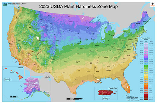
The USDA has updated its Plant Hardiness Zone Map for the first time in 11 years. | Download this photo.
USDA releases updated Plant Hardiness Zone Map
K-State expert says map is ‘critical’ for plant recommendations
Nov. 21, 2023
By Pat Melgares, K-State Research and Extension news service
MANHATTAN, Kan. – For the first time in 11 years, the U.S. Department of Agriculture has updated its Plant Hardiness Zone Map, which is historically the standard that gardeners and growers use to determine the perennial plants most likely to thrive at a location.
The update, said Kansas State University nursery crop production and marketing specialist Cheryl Boyer, is a big deal.
“It’s been a while since the maps have been updated because it’s a significant, coordinated effort,” said Boyer, noting that the maps are built based on data from 13,625 weather stations spanning 30 years.
“We use the plant hardiness zones for nearly all aspects of agriculture, horticulture and natural resources research and extension recommendations,” she said. “They influence our plant recommendations and production guidelines, both for crops and ornamental species.”
Boyer added that USDA’s Risk Management Agency uses the Plant Hardiness Zone Map to set some crop insurance standards for farmers. Other scientists use the data in models that might indicate the spread of weeds, insects or diseases.
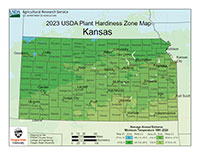
“The USDA plant hardiness zone map is a critical tool for plant recommendations,” Boyer said. “In Kansas, most of the state shifted about a half zone warmer. We still have pockets of Zone 5 in the north, but the range of Zone 7 in the southern part of Kansas is significantly larger.
“We should continue to focus on recommending plants that can handle Zone 5 plant hardiness because we will continue to experience extreme weather events, but we can also begin to expand our plant palette with species that originate in slightly warmer climates. This will also be reflected in a longer season for some food crops.”
Boyer served on a USDA technical review team that helped to develop the new map. The group included 40 plant professionals from industry, academic and government as well as “a few consumer horticultural enthusiasts – gardeners – from across the United States.”
The experts in the group included horticulturalists, botanists, agricultural meteorologists and climatologists.
“Our role was to serve as a sounding board and provide feedback for the development of the new map, tools, and to look closely at the weather data for our areas to confirm that it matched our lived experiences of the local weather environment,” Boyer said. “We discussed methodology, how the new maps will change plant hardiness zones and subsequent plant recommendations.”
The new map is available to view online at https://planthardiness.ars.usda.gov. Boyer said it’s designed to be searchable to locations as precise as one-half mile.
“This is helpful because, for example, urban areas tend to be heat islands and mountain tops tend to be colder than surrounding areas, so the new maps help identify those microclimates.”
Another online section, Tips for Growers, highlights resources to enhance the understanding and use of the new maps.
“Much of the information available is high-level guidance on how plants respond to the environment and what they need to survive and thrive, like light, soil, temperature, humidity and duration of exposure to cold,” Boyer said.
“Other resources provide different ways of learning, such as reading, watching a video, listening to a recording, and more. USDA provides educational information that can be applied broadly to the entire nation, while each state and county can provide more targeted advice based on local environments.”
More information on crop production and gardening also is available at local extension offices in Kansas, or online from K-State’s Department of Horticulture and Natural Resources.


