January 23, 2018
Wildland Fire Risk is Above Normal in Central, Southern Plains
Submitted by Jennifer Williams

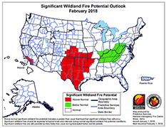
The central and southern Plains, including much of Texas, Oklahoma, and Kansas, have a higher than usual potential of wildland fire through April, according to Kansas State University scientists and a government organization that assesses such risks.
In its latest report, the National Interagency Coordination Center shows an elevated risk because of dry conditions in several states. The center is comprised of representatives from the Bureau of Land Management, Bureau of Indian Affairs, National Park Service, Forest Service, U.S. Fish and Wildlife Service, Federal Emergency Management Administration, and the National Association of State Foresters.
The report, the “National Significant Wildland Fire Potential Outlook,” provides an assessment of current weather and fuel conditions and how they will evolve in the coming months in order to assist fire managers in making decisions that will improve protection of life, property, and natural resources, increase firefighter safety and effectiveness, and reduce firefighting costs.
For the months of February through April in Kansas, the outlook highlights all but the northeast part of the state as having above-normal significant large fire potential that would require the mobilization of resources beyond the typical local response.
“Some parts of Kansas, especially the south-central and southwest areas, saw above-normal moisture during the growing season, with many reports of large to significant fuel loads as a result,” said Chip Redmond, meteorologist with the K-State Mesonet and an incident meteorologist. “Areas west of US-81 have seen considerable drying the previous months with many locations exceeding 90 days without a wetting rain. This, combined with persistent dry air masses, sunny skies, and breezy winds, are rapidly depleting any remnant moisture.”
While that’s not unusual for this time of year, he said, any deficit developed will be difficult to overcome without a period of above-normal moisture between now and March.
“With recent forecasts of mid-to-long range dryness continuing, we are setting the stage for some large fires in Kansas with heavy fuel loading and flash-type drought,” Redmond said.
Precipitation received during the crop growing season, April to September, is a determining factor for the upcoming fire season. In 2015 and 2016, above-normal precipitation was received which encouraged plant growth which then contributed to large fires the following winters. Despite a marginally drier period in 2017, the timing of above-normal moisture received in April and May was critical for supplying ample grass and fuel growth.
“This increased fuel load (plant growth) is a large concern for the next few months which are typically the driest period of the year for Kansas. With any strong system, the potential exists for large fires similar to what we have seen the last two years,” said Jason Hartman, the statewide Fire Protection Specialist with the Kansas Forest Service.
Current and Future Weather:
Much of Kansas began to dry out this past September. Areas of western Kansas haven’t received 0.1 inches of rain in more than 90 days. Above-normal temperatures in November and early December combined with gusty winds dried the soil surface. As a result, drought conditions are expanding across much of Kansas. According to the Drought Monitor at www.droughtmonitor.unl.edu, the condition of the entire state ranges from abnormally dry to severe drought.
Long-term forecasts suggest the dry period will continue through January, especially in western Kansas. Conditions may be aided somewhat by slightly below normal temperatures the rest of the month.
Beyond January, trends are more difficult to discern, said assistant climatologist, Mary Knapp. The February through March period is typically very dry in Kansas, averaging only 3.1 inches of total precipitation statewide. Any precipitation that does occur will only have short-term impacts on the dried out fuels until the arrival of spring rains.
“The biggest concern during the next few months,” said Knapp, “will be the occurrence of very warm days. These are typically associated with very dry air and high winds in advance of a strong storm system. Kansas’ largest wildfires are usually dependent on the shifting winds and the lack of moisture associated with these systems. Normally, Kansas will see several of these systems before one can eventually tap into the Gulf moisture and provide much-needed rainfall.”
Finally, the influence of precipitation type on wildland fires is important, she said. Snowfall can knock down or flatten standing grasses, which removes the vertical fuel load and can significantly decrease fire behavior. Despite some recent snows, a lack of heavy snowfall through January will continue to make grasses available and lead to suppression difficulties until a significant snowfall occurs.